


TopoDroid

คำอธิบายของTopoDroid
TopoDroid - Cave surveying on Android
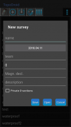
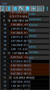
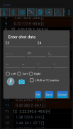
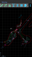
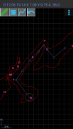
TopoDroid helps you to take survey data and accurate sketches while you are in the cave, so that you can detect errors in the data while you are still on the spot and correct them. TopoDroid has many functions to help you get the most out of a surveying trip. In this way, by the time you finish it, a working map is almost ready.
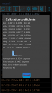
TopoDroid is designed to work *ONLY* with the DistoX (versions 1 and 2), although the survey data can be also entered by hand. TopoDroid has DistoX calibration functions, as well as other advanced DistoX functions.
NOTE. These DistoX are not a Leica products.
TopoDroid handles one survey session at a time. It is not a cave survey project manager. For that purpose there are many good PC programs, and TopoDroid exports survey data in several cave program formats (among them: therion, compass, visualtopo, walls, survex), as well as dxf, csv, kml, trackfile, shapefile. Sketches can be exported as therion, csurvey, dxf, svg, shapefile, and png image.
Full list of features, user manual, and docs on https://sites.google.com/site/speleoapps/home/topodroid
DISCLAIMER
This app is open-source, free and ad-free. It has no warranty. By using it you agree that the author is not responsible for any loss of data you might incur, or damage whatsoever, including damages to DistoX devices.
ANDROID PERMISSIONS
- TopoDroid requires the following permissions: WRITE_EXTERNAL_STORAGE, BLUETOOTH, BLUETOOTH_ADMIN
- Certain functions depend on these permissions:
CAMERA, RECORD_AUDIO, ACCESS_FINE_LOCATION.
- INTERNET permission is necessary to install translations of the user manual.
BETA and OLD APKS
TopoDroid has an open-beta program: opt-in link on the website.
A few apks of old versions are available on the website.
TRANSLATIONS
M. Guerrero (spanish), D. Ros (french), A. Kozhenkov (russian), V. Georgiev (bulgarian), M. Keller (german), F. Toso (italian), H.-J. Luo (chinese), P. Suru (hungarian), R. Severo (potuguese), M. Jurecka (slovak), K. Borgiel (polish), A. Pologea (romanian)
TopoDroid - การสำรวจถ้ำบน Android
TopoDroid ช่วยให้คุณใช้ข้อมูลการสำรวจและร่างที่ถูกต้องในขณะที่คุณอยู่ในถ้ำเพื่อให้คุณสามารถตรวจจับข้อผิดพลาดในข้อมูลในขณะที่คุณยังอยู่ในจุดที่ถูกต้องและแก้ไขได้ TopoDroid มีฟังก์ชั่นมากมายที่จะช่วยให้คุณได้รับประโยชน์สูงสุดจากการเดินทางสำรวจ ด้วยวิธีนี้เมื่อคุณทำเสร็จแผนที่ที่ใช้งานได้เกือบจะพร้อมแล้ว
TopoDroid ถูกออกแบบมาเพื่อทำงาน * เฉพาะ * กับ DistoX (รุ่น 1 และ 2) ถึงแม้ว่าข้อมูลการสำรวจสามารถป้อนด้วยมือได้ TopoDroid มีฟังก์ชั่นการสอบเทียบ DistoX และฟังก์ชั่นขั้นสูงอื่น ๆ ของ DistoX
บันทึก. DistoX เหล่านี้ไม่ใช่ผลิตภัณฑ์ Leica
TopoDroid จัดการหนึ่งการสำรวจครั้งละ มันไม่ใช่ผู้จัดการโครงการสำรวจถ้ำ เพื่อจุดประสงค์นั้นมีโปรแกรมพีซีที่ดีมากมายและ TopoDroid ส่งออกข้อมูลการสำรวจในรูปแบบโปรแกรมถ้ำหลายโปรแกรม (ในหมู่พวกเขา: therion, เข็มทิศ, visualtopo, กำแพง, พื้นผิวนูน) รวมถึง dxf, csv, kml, trackfile, shapefile ภาพร่างสามารถส่งออกเป็น therion, csurvey, dxf, svg, shapefile และรูปภาพ png
รายการคุณสมบัติเต็มรูปแบบคู่มือผู้ใช้และเอกสารใน https://sites.google.com/site/speleoapps/home/topodroid
การปฏิเสธความรับผิด
แอพนี้เป็นโอเพ่นซอร์สฟรีและไม่มีโฆษณา มันไม่มีการรับประกัน โดยการใช้คุณยอมรับว่าผู้เขียนจะไม่รับผิดชอบต่อการสูญเสียข้อมูลใด ๆ ที่คุณอาจได้รับหรือความเสียหายใด ๆ รวมถึงความเสียหายต่ออุปกรณ์ DistoX
สิทธิ์แอนดรอยด์
- TopoDroid ต้องการการอนุญาตดังต่อไปนี้: WRITE_EXTERNAL_STORAGE, BLUETOOTH, BLUETOOTH_ADMIN
- ฟังก์ชั่นบางอย่างขึ้นอยู่กับการอนุญาตเหล่านี้:
กล้อง RECORD_AUDIO, ACCESS_FINE_LOCATION
- จำเป็นต้องได้รับอนุญาตจาก INTERNET เพื่อทำการติดตั้งคำแปลของคู่มือผู้ใช้
BETA และ APK เก่า
TopoDroid มีโปรแกรมโอเพ่นเบต้า: ลิงค์เข้าร่วมในเว็บไซต์
มีบางเวอร์ชั่นเก่า ๆ บนเว็บไซต์
TRANSLATIONS
M. Guerrero (สเปน), D. Ros (ฝรั่งเศส), A. Kozhenkov (รัสเซีย), V. Georgiev (บัลแกเรีย), M. Keller (เยอรมัน), F. Toso (อิตาลี), H.-J. Luo (จีน), P. Suru (ฮังการี), R. Severo (ภาษาโปรตุเกส), M. Jurecka (สโลวาเกีย), K. Borgiel (โปแลนด์), A. Pologea (โรมาเนีย)


